Worlds Apart: Postcodes with the Highest and Lowest Poverty Rates in Today’s Australia
- NATSEM, University of Canberra, Australia. This article was originally presented to National Social Policy Conference "2001", Sydney, July 2001.
Abstract
NATSEM has recently developed the capacity to estimate poverty at a detailed regional level. This paper describes the techniques and estimates the level of poverty and characteristics of people in poverty in the postcodes with the highest and lowest poverty rates in each state.
1. Introduction
This paper aims to add to existing research on poverty and regional diversity by exploring the extent of poverty in small regional areas. Poverty analysis on a regional basis has previously been severely hampered by a lack of suitable data. The unit record files from the Australian Bureau of Statistics (ABS) household expenditure and income surveys allow analysis at state and very broad regional levels. However, such disaggregation results in small sample sizes and the two Territories are usually collapsed together by the ABS, so that results cannot be derived for either the ACT or the Northern Territory. While the national population Census provides data for small regions (down to Census Collector District level – about 200 households), income data are limited to gross household income ranges. Gross household income is not generally regarded as the best income measure for poverty analysis, with most analysts preferring an after-tax income measure, adjusted by an equivalence scale to take account of varying needs due to differences in household size and composition (for example, ABS, 1998; Saunders, 1996; Harding and Szukalska, 2000). A second problem with the Census data is that, because the income data are in ranges, the ‘poverty line’ has to be set at the boundary of one of the income ranges.
NATSEM has recently developed the capacity to estimate poverty at a detailed regional level. Marketinfo is a cutting edge synthetic regional data model that provides sociodemographic, income and expenditure data for each Census Collectors District (CCD). The Marketinfo model blends the 1996 Census CDATA and the Household Expenditure Survey (HES) unit record file, so as to effectively provide a synthetic HES unit record file for every CCD in Australia.
In 2000 NATSEM used Marketinfo/99 to provide a snapshot of poverty in the ACT – including the demographic characteristics and spending patterns of people in poverty (Harding et al., 2000). The information at CCD level was aggregated to provide estimates of the number of people living in poverty in each of the statistical subdivisions (roughly equivalent to the town centres) of the ACT.
With the release of the 1998-99 Household Expenditure Survey, a new version of Marketinfo – Marketinfo/2001 – has recently been developed. The postcode weights from Marketinfo/2001 were combined in this study with the income information from the HES to give preliminary estimates of poverty rates by postcode in 1998-99 and to look at the characteristics of people in poverty in the postcodes in each state with the highest and lowest poverty rates. We also examined the characteristics of each of the selected postcodes to see what factors were driving particularly high and low poverty rates. This is a new field of research and this paper should be seen as a presentation of preliminary results and our first attempt at using techniques that will become more sophisticated over time.
2. Data and methodology
2.1 Data Source
This study uses income and demographic information from the 1998-99 Household Expenditure Survey, combined with postcode weights for 2000 derived from Marketinfo/2001, to derive regional poverty estimates.1 It is hoped that future work on this project will allow us to use income information from STINMOD/01A, a HES-based version of NATSEM’s static microsimulation model, rather than the 1998-99 tax and income figures recorded in the original 1998-99 HES. STINMOD simulates income tax and the major cash transfer programs administered by the Department of Family and Community Services and the Department of Veterans’ Affairs (Bray, 2000). The latest version of STINMOD/01A models the major changes to Australia’s tax and transfer systems introduced on 1 July 2000. The ABS has not yet conducted an income survey since the tax reforms so STINMOD will provide a unique opportunity to estimate how individual families fare under the New Tax System (TNTS).
Marketinfo/2001 is a synthetic data set created by combining the 1996 Census CDATA with the 1998-99 Household Expenditure Survey (HES) unit record file. The Census surveys the whole population and provides detailed sociodemographic data on a street block (Census Collector District – CCD) level. The HES provides more detailed income information than the Census and it also includes extensive expenditure data. Marketinfo uses sociodemographic variables common to the Census and the HES to merge the two surveys. The resulting micro data set contains sociodemographic, income and expenditure information for each CCD in Australia. This method overcomes the sample size problems of using sample surveys such as the HES directly for analysis at a state or broad regional level. It also allows analysis at a detailed regional level, such as CCDs, postcodes, statistical local areas, statistical subdivisions or electorates. In this study, the information was aggregated to postcode level and poverty rates were estimated for each postcode so as to identify the postcodes in each state with the highest and lowest poverty rates.
2.1.1 Ageing the population and data
The 1996 sociodemographic profiles shown for each Census Collectors District in the 1996 Census have been uprated to estimated 2000 population levels using ABS data on dwelling commencements and estimates of demolitions for each CCD, along with labour force survey data on labour force characteristics by region. The incomes are as recorded in the HES unit record file.
2.1.2 Unit of analysis
Marketinfo is derived from the Census and the HES and hence provides data at the household level. Consequently, this paper uses households as the unit of analysis. This effectively assumes that there is complete income sharing within households. The HES person file was also used to derive some variables.
2.1.3 Validity
The results of this study are based on simulated data and the techniques are at the cutting edge of poverty research. However, the model has solid foundations in terms of the original data and the techniques. Its predecessors have been used for market research purposes since 1993 and have been benchmarked against other data sources. Policy makers frequently make us of simulated data from high quality model when actual data are not available. Nonetheless, it should be appreciated that this is among the first of NATSEM’s attempts to use the new synthetic regional income database for poverty analysis and that subsequent efforts will no doubt embody more sophisticated techniques and more recent data.
In a major report for the Smith Family written in 2000, NATSEM estimated the before-housing Henderson half-average income poverty rate in 1999 to be 13.3 per cent (Harding and Szukalska, 2000). These results were derived using the 1997-98 Survey of Income and Housing Costs (SIHC) with incomes uprated to 1999 (Harding and Szukalska, 1999). The Australian average poverty rate in this study, which uses the 1998-99 Household Expenditure Survey with Marketinfo weights, is estimated to be 10.3 per cent.
Part of the difference can be attributed to the fact that this study uses households as the unit of analysis while the Smith Family report was based on income unit analysis. An analysis of the poverty rates at income unit and household level in the 1997-98 SIHC showed that household level poverty rates were approximately 2.5 percentage points less than income unit level rates.
Another possible source of difference is the varying income distributions between the HES and the SIHC – with our initial explorations suggesting that the HES income distribution may be more equal than that shown in the SIHC. For these reasons, this paper should be seen as a work-in-progress and the results as indicative rather than definitive.
2.2 Defining poverty
Australians generally do not suffer the severe material deprivation evident in some developing countries. This affects our definition of poverty. In this study, poverty applies not only to individuals without food or shelter, but also to those whose living standards fall below some overall community standard. This relative poverty definition underpins most estimates of the number of Australians in poverty (ABS 1998).
There is no universally accepted measure of poverty. All of the decisions made by analysts in defining and measuring poverty are subject to heated debate. In this report we analyse the number of people living in poverty using the half-average income poverty line allied with the Henderson detailed equivalence scales. This Henderson half-average poverty line is defined for a benchmark household type, such as a couple with two children, and then the Henderson equivalence scales are used to determine comparable poverty lines for other types of households. If a household’s disposable (that is, after income tax) income falls below the poverty line, we deem that they are in poverty. The poverty rate (or risk) is the proportion of all households of a particular type that fall below a given poverty line. In future work we hope to examine the consistency of our results by using other poverty measures, such as the Henderson poverty line, the Henderson half-median, the modified OECD half-median and the ‘International scale’ half-median poverty lines (see Harding and Szukalska (2000) for more information on these various poverty lines).
2.2.1 Equivalence scales
The financial circumstances of a household are dependent not only on the income of the household but also on its composition. For example, a single person with a disposable income of $19 000 is unlikely to suffer from the same degree of poverty as a couple with four children on the same income. Equivalence scales provide a way of defining poverty levels for families of different composition.
Results can vary greatly depending on the equivalence scale used. The detailed Henderson equivalence scale, which was used in this study, was derived from a survey of household budgets and costs in New York in the 1950s. Despite this, it has been widely used in Australia as a standard method for equivalising incomes. The detailed Henderson equivalence scale takes account of the gender, age and labour force status of the head, the age and labour force status of the spouse and other adults, and the ages of dependent children. The original Henderson approach assigned higher ‘working’ points to people who were either working full-time or unemployed and looking for full-time work. In this study, the ’working’ points have also been assigned to those who are working part-time and to those who are unemployed and looking for part-time work.
The Henderson equivalence scale has been applied at the household level. Because of this, we have given all non-dependent adults who live in the household the same points as a spouse. In the case of a household consisting of three unrelated single people we assign the reference points to the person deemed to be the household head and points equivalent to spouse points to the other two. Other studies using the family or the ABS income unit as the unit of analysis would, in contrast, have assigned head points to all three adults. This is one key reason why our results vary from other poverty estimates (for example, in Harding and Szukalska, 2000). The 1996 Census and consequently Marketinfo/2001 do not, however, allow easy analysis at any level other than the household.
2.2.2 Poverty lines
Poverty lines are levels of income and are different for each type of income unit – in our study the income unit is the household. If a household’s income falls below the poverty line for that type of household then the household is considered to be in poverty.
The Henderson half-average poverty measure sets the standard poverty line at half of the average equivalent disposable household income for a standard household. The standard household consists of a couple both under 40 years old with the husband working and the wife not in the labour force with 2 children, a boy aged 6-14 and a girl aged under 6 years old. The Henderson half-average poverty line was $400 per week. (This is looking at all people in Australia, not just those living in the selected postcodes.) Poverty lines for other family types are derived using the Henderson detailed equivalence scales.
There is no consensus about whether the median or the average is to be preferred as the poverty benchmark, with available studies using both (for example, Layte et al., 2000; Strengmann-Kuhn, 2000). The median has the advantage of being less affected by extreme values than the average. For example, large increases in the highest incomes will cause the average to increase but alone will not have an effect on the median. On the other hand, during an era of rising income inequality, there is concern that the incomes of those at the top end might increase substantially, while still leaving median incomes — and thus the poverty rate — unaffected if the poverty line is set at half median income. For that reason we have chosen to use the half-average income poverty line in this study.
3. Poverty rates in poor and rich postcodes
3.1 Poverty rates
Using the methods described above, before housing Henderson half-average poverty rates were estimated for each of the postcodes in Australia. From these, we chose the postcodes with the highest and lowest poverty rates in each state. We excluded postcodes with fewer than 1000 households as we chose to focus on postcodes of reasonable size rather than those that were small and often special in their nature. For example, Kapooka had a low poverty rate but consisted of only 92 households associated with an army base. Conversely, Brim in Victoria had a low estimated gross average household income of only $23,168 and was assigned one of the highest recorded poverty rates in our study. However, we estimated that less than 100 households lived in Brim, so we excluded it from our analysis, as such a small size increased the possibility of sampling or other errors. Table 1 lists the number of postcodes in each state and the number that were excluded because they contain less than 1000 households.
Number of postcodes and number with less than 1000 households, by state
| Total number of postcodes | Number of postcodes with less than 1000 households | |
|---|---|---|
| New South Wales | 589 | 181 |
| Victoria | 625 | 305 |
| Queensland | 392 | 154 |
| South Australia | 321 | 178 |
| Western Australia | 289 | 171 |
| Tasmania | 108 | 62 |
-
Source: 1998-99 HES and Marketinfo/2001 weights.
Tables 2–7 provide an overview of the poverty rates in the top and bottom postcodes in each state compared with the relevant state and Australian averages.
NSW postcodes with highest and lowest poverty rates
| Highest poverty rate | Lowest poverty rate | NSW average | Australian average | |
|---|---|---|---|---|
| Postcode number | 2834 | 2088 | ||
| Postcode name | Lightning Ridge | Spit Junction | ||
| Poverty rates | % | % | % | % |
| People | 25.9 | 0.7 | 9.8 | 10.3 |
| Adults | 22.4 | 0.9 | 8.8 | 9.3 |
| Children | 39.6 | 0.2 | 12.5 | 12.9 |
-
Note: Poverty rates are measured at the household level, which means they are not directly comparable to most other poverty studies. Only includes postcodes with over 1000 households.
-
Source: 1998-99 HES and Marketinfo/2001 weights.
-
*
Using the Henderson half average poverty line
Victorian postcodes with highest and lowest poverty rates
| Highest poverty rate | Lowest poverty rate | Victorian average | Australian average | |
|---|---|---|---|---|
| Postcode number | 3053 | 3186 | ||
| Postcode name | Carlton South | Brighton | ||
| Poverty rates | % | % | % | % |
| People | 25.2 | 1.4 | 10.1 | 10.3 |
| Adults | 22.4 | 1.3 | 9.2 | 9.3 |
| Children | 38.5 | 1.8 | 12.8 | 12.9 |
-
Note: Poverty rates are measured at the household level, which means they are not directly comparable to most other poverty studies.
-
Source: 1998-99 HES and Marketinfo/2001 weights.
-
*
Using the Henderson half average poverty line.
Queensland postcodes with highest and lowest poverty rates
| Highest poverty rate | Lowest poverty rate | Queensland average | Australian average | |
|---|---|---|---|---|
| Postcode number | 4671 | 4069 | ||
| Postcode name | Gin Gin | Kenmore | ||
| Poverty rates | % | % | % | % |
| People | 21.6 | 3.4 | 10.6 | 10.3 |
| Adults | 20.0 | 2.9 | 9.6 | 9.3 |
| Children | 25.9 | 4.6 | 13.3 | 12.9 |
-
Note: Poverty rates are measured at the household level, which means they are not directly comparable to most other poverty studies.
-
Source: 1998-99 HES and Marketinfo/2001 weights.
-
*
Using the Henderson half average poverty line.
South Australian postcodes with highest and lowest poverty rates
| Highest poverty rate | Lowest poverty rate | South Australian average | Australian average | |
|---|---|---|---|---|
| Postcode number | 5010 | 5725 | ||
| Postcode name | Ferryden Park | Roxby Downs | ||
| Poverty rates | % | % | % | % |
| People | 29.8 | 1.4 | 12.1 | 10.3 |
| Adults | 27.2 | 0.9 | 11.2 | 9.3 |
| Children | 36.9 | 2.6 | 14.6 | 12.9 |
-
Note: Poverty rates are measured at the household level, which means they are not directly comparable to most other poverty studies.
-
Source: 1998-99 HES and Marketinfo/2001 weights.
-
*
Using the Henderson half average poverty line.
West Australian postcodes with highest and lowest poverty rates
| Highest poverty rate | Lowest poverty rate | West Australian average | Australian average | |
|---|---|---|---|---|
| Postcode number | 6000 | 6015 | ||
| Postcode name | Perth City | City Beach | ||
| Poverty rates | % | % | % | % |
| People | 19.0 | 2.8 | 10.3 | 10.3 |
| Adults | 18.5 | 2.5 | 9.4 | 9.3 |
| Children | 23.3 | 3.5 | 12.7 | 12.9 |
-
Note: Poverty rates are measured at the household level, which means they are not directly comparable to most other poverty studies.
-
Source: 1998-99 HES and Marketinfo/2001 weights.
-
*
Using the Henderson half average poverty line.
Tasmanian postcodes with highest and lowest poverty rates
| Highest poverty rate | Lowest poverty rate | Tasmanian average | Australian average | |
|---|---|---|---|---|
| Postcode number | 7215 | 7053 | ||
| Postcode name | St. Mary’s | Taroona | ||
| Poverty rates | % | % | % | % |
| People | 20.5 | 6.4 | 13.0 | 10.3 |
| Adults | 18.5 | 6.2 | 12.3 | 9.3 |
| Children | 26.4 | 7.0 | 14.9 | 12.9 |
-
Note: Poverty rates are measured at the household level, which means they are not directly comparable to most other poverty studies.
-
Source: 1998-99 HES and Marketinfo/2001 weights.
-
*
Using the Henderson half average poverty line.
The postcode with the highest poverty rate is Ferryden Park, a suburb of Adelaide, where almost one third of people are estimated to live in poverty. This contrasts with the mining community of Roxby Downs, 560 km north of Adelaide, which has a poverty rate of only 1.4 per cent.
The 2088 postcode on Sydney’s north shore, which includes the suburbs of Mosman and Balmoral, has a poverty rate of just 0.7 per cent. While New South Wales has the lowest average poverty rate of all the states (9.8 per cent), the postcode of Lightning Ridge in the west of the state has over one-quarter of its people and 40 per cent of its children living in poverty.
Victoria has poverty rates below the national average, with the lowest poverty rate in the Melbourne bayside suburb of Brighton and the highest in Carlton South, close to the University of Melbourne.
Tasmania has the highest average poverty rate of the states, at 13 per cent, but there is less diversity between the top and bottom postcodes. Taroona, an outer suburb of Hobart, has Tasmania’s lowest poverty rate of 6.4 per cent (although this is significantly higher than the lowest poverty rate in any other state). St. Mary’s has Tasmania’s highest poverty rate, with about one-fifth of its residents in poverty.
Most of the postcodes with the lowest poverty rates are in metropolitan areas — the exception is Roxby Downs — but the postcodes with the highest poverty rates are more diverse. Lightning Ridge, Gin Gin and St. Mary’s are rural, and Carlton South, Ferryden Park and Perth City are metropolitan.
Children face a higher risk of being in poverty than adults and the national figures show that child poverty is some three percentage points higher than adult poverty. The state averages show similar patterns. However, in the postcodes with the highest poverty rates there is generally a much greater difference in the rates of poverty for children and adults. For example, in Lightning Ridge, the child poverty rate of almost 40 per cent compares with an adult poverty rate of 22 per cent. In three out of the top six poverty postcodes examined in Tables 2–7, almost two out of every five children were in poverty, compared with only one in every eight children nationally.
3.2 Characteristics of those in poverty in the poorest postcodes
What types of households are in poverty in the poorest postcodes in each state? Table 8 shows the characteristics of households in poverty compared with the national averages for households in poverty. It is clear that the composition of poor households can be very different in varying localities, even when the total poverty rates within postcodes are fairly similar.
Characteristics of people in poverty in poorest postcodes and Australia
| Postcode | 2834 | 3053 | 4671 | 5010 | 6000 | 7215 | Australia |
|---|---|---|---|---|---|---|---|
| % of total in poverty | |||||||
| Age of the household reference person | |||||||
| Less than 25 years | 2.1 | 10.3 | 0.8 | 9.5 | 23.2 | 4.8 | 4.6 |
| 25-34 years | 35.2 | 24.7 | 21.6 | 31.6 | 28.4 | 22.9 | 25.9 |
| 35-44 years | 22.6 | 32.5 | 35.8 | 22.9 | 26 | 32.5 | 30.7 |
| 45-54 years | 19.9 | 22.1 | 17.9 | 19.8 | 14 | 18.6 | 17.1 |
| 55-64 years | 13.7 | 3.4 | 15.4 | 3.9 | 4.6 | 13.8 | 10.7 |
| 65 years or more | 6.6 | 7 | 8.6 | 12.3 | 3.9 | 7.3 | 11.1 |
| 100 | 100 | 100 | 100 | 100 | 100 | 100 | |
| Sex of the reference person | |||||||
| Male | 43.3 | 52.6 | 43 | 42.1 | 51.4 | 36.9 | 37.6 |
| Female | 56.7 | 47.4 | 57 | 57.9 | 48.6 | 63.1 | 62.4 |
| 100 | 100 | 100 | 100 | 100 | 100 | 100 | |
| Labour force status of the reference person | |||||||
| Employee – full-time | 1.9 | 3.9 | 4.7 | 3.8 | 1.2 | 3.8 | 5.6 |
| Employee – part-time | 17 | 6.3 | 16.2 | 8.5 | 16.9 | 15 | 13.8 |
| Self employed | 14.3 | 7.7 | 18.9 | 3.5 | 4.7 | 15.6 | 15 |
| Unemployed | 24.5 | 24.3 | 16.3 | 28.7 | 26.6 | 12.2 | 13.8 |
| Not in the labour force | 42.3 | 57.7 | 43.8 | 55.6 | 50.7 | 53.4 | 51.7 |
| 100 | 100 | 100 | 100 | 100 | 100 | 100 | |
| Principal source of income for the household | |||||||
| Wage and salary | 9.9 | 7.6 | 17.1 | 10.6 | 13.4 | 13.1 | 16.3 |
| Self-employed | 7 | 3.5 | 9.2 | 0.3 | 5.1 | 10 | 7.6 |
| Other | 11.2 | 28.6 | 8.7 | 11.8 | 19.1 | 8.7 | 12.7 |
| Government cash benefits | 68.3 | 60.2 | 59.6 | 74.3 | 56.8 | 63.6 | 57.3 |
| Zero or negative income | 3.5 | 0.1 | 5.4 | 3 | 5.5 | 4.7 | 6 |
| 100 | 100 | 100 | 100 | 100 | 100 | 100 | |
| Occupation of the reference person | |||||||
| NA (ie not working in occupation) | 66.9 | 82 | 60.2 | 84.3 | 77.3 | 65.6 | 65.6 |
| Managers and professionals | 9 | 12.6 | 17.6 | 2.9 | 8.7 | 13.9 | 13.7 |
| Tradespersons | 4.7 | 0 | 3.1 | 1.6 | 0.1 | 3.9 | 3.1 |
| Clerical, sales and service | 10.8 | 0.9 | 9.8 | 4.8 | 6.7 | 9.8 | 9.8 |
| Labourers, production and transport workers | 8.7 | 4.5 | 9.4 | 6.4 | 7.2 | 6.8 | 7.8 |
| 100 | 100 | 100 | 100 | 100 | 100 | 100 | |
| Tenure type | |||||||
| Owner | 43.8 | 13.9 | 42.4 | 10.9 | 18.6 | 43.2 | 34.9 |
| Purchaser | 15.6 | 10.1 | 26.4 | 7.7 | 7.3 | 23.8 | 22.8 |
| Public housing | 2.1 | 36.9 | 22.7 | 78.4 | 14.6 | 3.7 | 10.3 |
| Private renter | 28.8 | 38.4 | 8.4 | 2.3 | 55 | 21.9 | 27.1 |
| Other, rent-free | 9.7 | 0.7 | 0 | 0.7 | 4.5 | 7.4 | 5 |
| 100 | 100 | 100 | 100 | 100 | 100 | 100 | |
| Marital status of the reference person | |||||||
| Never Married | 13.1 | 30.9 | 6.1 | 30.1 | 46.9 | 8.8 | 13 |
| Separated/divorced/widowed | 26.6 | 19 | 16.7 | 20 | 14 | 17.1 | 23.1 |
| Married | 60.3 | 50.1 | 77.2 | 49.9 | 39 | 74.1 | 63.9 |
| 100 | 100 | 100 | 100 | 100 | 100 | 100 | |
| Household type | |||||||
| Single person | 23.7 | 21.6 | 12.3 | 20.6 | 47.1 | 16.1 | 15.4 |
| Couple only | 14.1 | 7.8 | 20.4 | 13.2 | 9.3 | 16.2 | 15.4 |
| Couple with children | 42.7 | 39.2 | 49.6 | 32.8 | 24.2 | 53.8 | 40.7 |
| Sole parent | 14.5 | 20.3 | 10.4 | 28.3 | 9.5 | 9.9 | 20 |
| Multiple families | 5 | 11.1 | 7.3 | 5.1 | 10 | 4 | 8.5 |
| 100 | 100 | 100 | 100 | 100 | 100 | 100 | |
| Number of dependents in the household | |||||||
| None | 46 | 39 | 39.8 | 37.3 | 68.2 | 37.9 | 38.3 |
| One | 6.6 | 20.2 | 13 | 18.7 | 18 | 12.7 | 13.4 |
| Two | 15.8 | 39.7 | 15.5 | 31.7 | 13.5 | 20.4 | 22.2 |
| Three | 20 | 0 | 21.2 | 1 | 0.3 | 21.5 | 18.6 |
| Four | 11.5 | 1 | 8.1 | 11.3 | 0 | 7.2 | 6.4 |
| Five or more | 0.1 | 0 | 2.4 | 0 | 0 | 0.2 | 1 |
| 100 | 100 | 100 | 100 | 100 | 100 | 100 | |
| Country of birth of the reference person | |||||||
| Australia | 81.7 | 29.4 | 76.2 | 41.7 | 51.4 | 86.6 | 65.4 |
| Other | 4.4 | 12.8 | 5.2 | 28.4 | 10.3 | 2.7 | 8.2 |
| Europe/former USSR | 13 | 24.6 | 13.7 | 18 | 19.6 | 10.1 | 14.6 |
| Asia | 0.8 | 33.2 | 5 | 11.9 | 18.6 | 0.6 | 11.7 |
| 100 | 100 | 100 | 100 | 100 | 100 | 100 | |
-
Source: 1998-99 HES and Marketinfo/2001 weights.
-
*
Using the Henderson half average poverty line.
3.2.1 Postcode 2834- Lightning Ridge
Poor households in Lightning Ridge are more likely than poor Australian households generally to have government cash benefits as their principal source of income. While 57 per cent of poor households in Australia rely on government benefits as their main income source, almost seven in every 10 households in Lightning Ridge do. Conversely, while 16 per cent of poor Australian households have wages and salaries as their main income source, less than one-tenth of households in Lightning Ridge do. This parallels the fact that the proportion of people in Lightning Ridge living in a household where the head is unemployed is significantly greater than the national average, while the proportion where the head is a full-time employee is considerably lower. Poor households in Lightning Ridge are more likely than Australian poor households generally to have a head born in Australia (80 per cent compared with 65 per cent) and almost none have a head born in Asia. Poor households in Lightning Ridge are less likely than the Australian average to live in public housing and more likely to be single person households.
3.2.2 Postcode 3053-Carlton South
The majority of poor residents in the postcode of Carlton South live in a household headed by a man. Seventy per cent live in a household where the head is not born in Australia, which compares with 35 per cent of all poor Australians. The head of the household is more likely to have never married and be under 25 than for poor households nationally. Figure 1 shows that almost one-quarter of the poor in Carlton South live in a household where the head is unemployed and almost six in 10 live a household with the head is not in the labour force. Only 18 per cent have a head that is working. These figure are quite different to the national average. About half of all poor Australians are not in the labour force and another 14 per cent are unemployed. Over three out of 10 poor Australians have some sort of employment. Thus the poor of Carlton South are much more likely to live in a household where the head is not working. In Carlton South, 37 per cent of poor households live in public housing – about 3.5 times the Australian average. Overall, therefore, poverty in Carlton South seems to be due to large numbers of students, unemployed, migrants and a concentration of public housing.
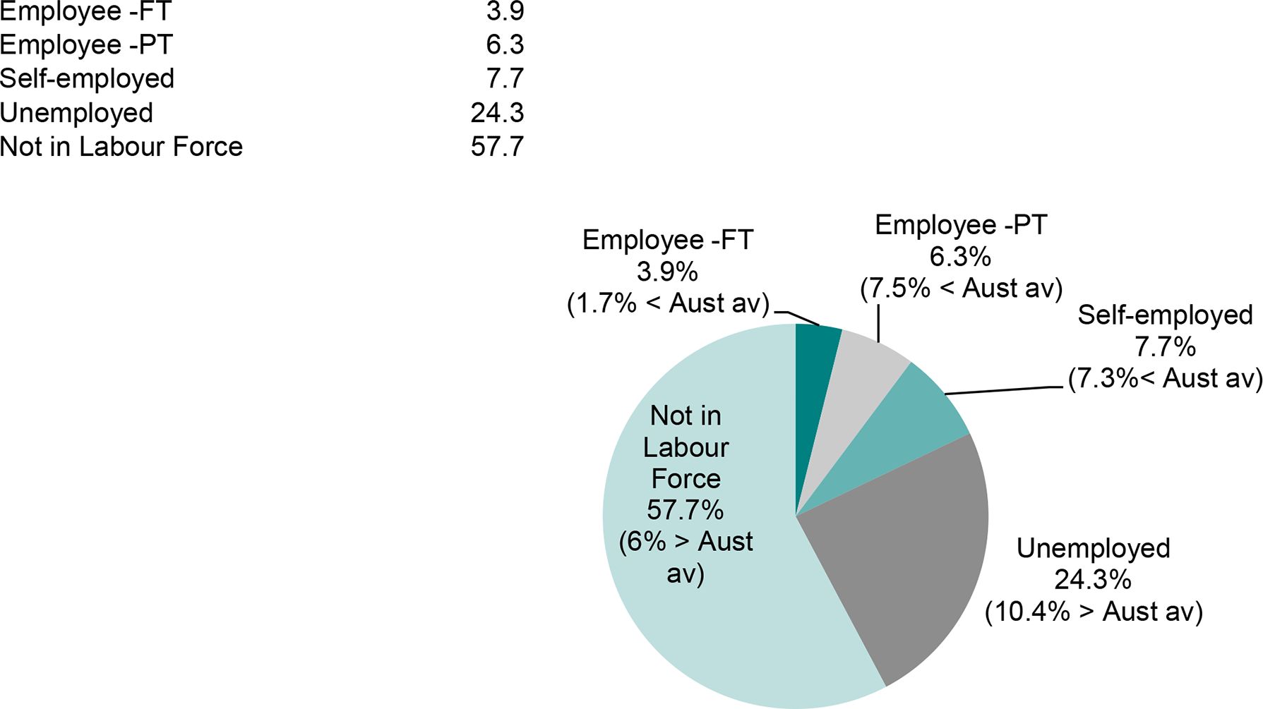

Labour force status of household reference person in poor households in Carlton South (and percentage point difference from national average). Data source: 1998-99 HES and Marketinfo/2001 weights.
3.2.3 Postcode 4671 – Gin Gin
The picture of poverty in Gin Gin is quite different from that of Carlton South. Less than one percent of poor residents live in a household headed by a person under 25. The head is more likely to be middle-aged – 7 in 10 poor households are headed by a person aged 35-65 compared with 58 per cent of all poor Australian households – and are much more likely to be married. Compared with the Australian average, there are more poor households that are couples, either with or without children. A significant proportion of the poor in this postcode live in a household where the head is employed – 4.7 per cent are employed full-time, 16.2 per cent part-time and 18.3 per cent are self-employed. Correspondingly, over one quarter of households rely on income from wages and salaries or self-employment as their principal source of income. Compared with the national average, a greater proportion of the poor in Gin Gin live in public housing or are home owners/purchasers, and they are more likely to be Australian born.
3.2.4 Postcode 5010 – Ferryden Park
The poor of Ferryden Park tend to live in households where the head has a very high chance of being unemployed (28.7 per cent compared with the national average of 13.8 per cent), never married (30.1 per cent compared with 13.0 per cent generally) and not born in Australia (58.3 per cent compared with 34.6 per cent) (Figure 2). Most poor households in this postcode live in public housing (a striking 78.4 per cent compared with the national average of 10.3 per cent) and almost three-quarters have government cash benefits as their principal income source.
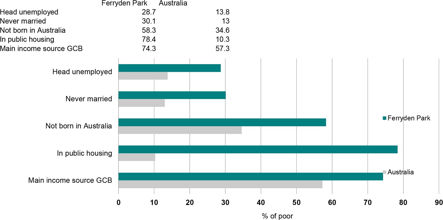

Selected household characteristics of poor residents of Ferryden Park and all poor Australians. Data source: 1998-99 HES and Marketinfo/2001 weights.
3.2.5 Postcode 6000 – Perth City
The picture of poverty in the Perth City postcode is one of young, single people without dependents. Over 23 per cent of poor people in this postcode live in a household headed by a person under 25 years of age. This compares with 4.6 per cent of poor Australians. Almost half have never married (compared with 13 per cent nationally) and a similar proportion lives in single person households (compared with 15 per cent of Australia’s poor). Over 68 per cent live in a household without dependent children. The majority of the poor in Perth City live in households headed by a male (51 per cent, compared with 38 per cent for Australia). Over one-quarter is unemployed and 55 per cent are private renters.
3.2.6 Postcode 7215 – St. Mary’s
The poor in St. Mary’s in Tasmania have a profile more like the Australian average than any of the other postcodes profiled here. Poor households in St. Mary’s are more likely than the poor Australian households generally to have government cash benefits as their main income source and less likely to rely mainly on wages and salaries. An Australian-born person heads almost 9 in 10 poor households in St. Mary’s and only 3.7 per cent of poor households there live in public housing, compared with one-tenth nationally. Poor households in this postcode are more likely to have a head that is married and more likely to be a couple with children.
3.3 Characteristics of the poor and rich postcodes
What causes a postcode to have high or low poverty rates? Table 9 looks at some of the key characteristics of those living in each of the postcodes with high poverty rates while Table 10 looks at the characteristics of those living in postcodes with low poverty rates.
Characteristics of the high poverty postcodes
| 2834 | 3053 | 4671 | 5010 | 6000 | 7215 | Aust-ralia | |
|---|---|---|---|---|---|---|---|
| Average total income (annual) | 25 164 | 40 011 | 28 955 | 22 480 | 36 995 | 27 568 | 45 574 |
| Average disposable income (annual) | 21 999 | 31 740 | 25 471 | 20 600 | 29 188 | 23 993 | 36 581 |
| Age of the household reference person | |||||||
| Less than 25 years | 3.5 | 21.7 | 1.9 | 7.5 | 16.2 | 3.8 | 4.2 |
| 25-34 years | 22.1 | 28.1 | 14.1 | 22.4 | 27.9 | 18.3 | 20.2 |
| 35-44 years | 22.8 | 21.5 | 32.1 | 26.6 | 21.4 | 29.8 | 29.1 |
| 45-54 years | 19.8 | 14.5 | 23.1 | 16.3 | 17.9 | 19.6 | 22.9 |
| 55-64 years | 18 | 7.3 | 15.3 | 11.3 | 7.3 | 14.2 | 11.4 |
| 65 years or more | 13.9 | 6.9 | 13.6 | 15.9 | 9.3 | 14.2 | 12.2 |
| Sex of the reference person | |||||||
| Male | 55.9 | 55.7 | 58.2 | 53.1 | 64 | 56.3 | 63 |
| Female | 44.1 | 44.3 | 41.8 | 46.9 | 36 | 43.7 | 37 |
| Labour force status of reference person | |||||||
| Employee – full-time | 22.3 | 41 | 29.5 | 26.4 | 44.8 | 28 | 49.6 |
| Employee – part-time | 14.8 | 12.7 | 12.6 | 15.9 | 11 | 14.6 | 10.6 |
| Self employed | 8.8 | 2.8 | 12 | 1.7 | 3.5 | 10.7 | 7.8 |
| Unemployed | 9.3 | 7 | 5 | 9 | 6.9 | 3.5 | 2.4 |
| Not in the labour force | 44.8 | 36.6 | 40.8 | 47 | 33.8 | 43.1 | 29.6 |
| Principal source of income for the household | |||||||
| Wage and salary | 34.4 | 50.4 | 42.1 | 37.2 | 54.7 | 38.9 | 61.4 |
| Self-employed | 6.9 | 2 | 10.7 | 0.6 | 3.9 | 10.2 | 6.8 |
| Other | 8.5 | 12.6 | 7.4 | 4.5 | 15.9 | 8.3 | 6.6 |
| Government cash benefits | 49.3 | 35 | 38.7 | 56.9 | 24.5 | 41.7 | 24.6 |
| Zero or negative income | 0.9 | 0 | 1.2 | 0.9 | 1.1 | 1 | 0.6 |
| Occupation of the reference person | |||||||
| NA (ie not working in occupation) | 54.1 | 43.6 | 45.9 | 56 | 40.7 | 46.6 | 32 |
| Managers and professionals | 12.3 | 36.4 | 18.3 | 7 | 35.3 | 20.7 | 32.3 |
| Tradespersons | 6.3 | 2.2 | 6.9 | 7.3 | 3.2 | 10.3 | 10.1 |
| Clerical, sales and service | 12.1 | 10.6 | 9.9 | 6.1 | 11.2 | 9.8 | 13.1 |
| Labourers, production and transport workers | 15.2 | 7.2 | 19 | 23.6 | 9.6 | 12.6 | 12.6 |
| Tenure type | |||||||
| Owner | 57.8 | 14.9 | 45.8 | 11.2 | 19.6 | 45 | 36.9 |
| Purchaser | 10.9 | 10.6 | 32.1 | 12.9 | 16.7 | 29.8 | 33.8 |
| Public housing | 1.9 | 21 | 17.5 | 68 | 4.8 | 2.8 | 5 |
| Private renter | 22.9 | 52.1 | 4.6 | 7.6 | 56.5 | 18.7 | 22.2 |
| Other, rent-free | 6.4 | 1.3 | 0 | 0.4 | 2.3 | 3.6 | 2.2 |
| Marital status of the reference person | |||||||
| Never Married | 14.2 | 36 | 5 | 21 | 38.1 | 7.8 | 10.4 |
| Separated/divorced/widowed | 24.1 | 17.4 | 14.8 | 22.5 | 16.1 | 15.6 | 16.4 |
| Married | 61.7 | 46.6 | 80.2 | 56.5 | 45.8 | 76.6 | 73.2 |
| Household type | |||||||
| Single person | 20.6 | 17 | 7.5 | 14.2 | 33.1 | 12.2 | 9.6 |
| Couple only | 23.5 | 14.6 | 26.7 | 17.1 | 22.9 | 27.6 | 19.7 |
| Couple with children | 32.6 | 26.1 | 45.5 | 34.1 | 20.5 | 45.4 | 45.4 |
| Sole parent | 12.1 | 14 | 9.1 | 24.5 | 7.4 | 8.9 | 11.5 |
| Multiple families | 11.2 | 28.3 | 11.2 | 10.2 | 16.1 | 5.9 | 13.7 |
| Number of dependents in the household | |||||||
| None | 60.3 | 59.5 | 46.9 | 46.1 | 73 | 49.1 | 45.3 |
| One | 10.7 | 17.8 | 11.6 | 19.2 | 19.2 | 13 | 16.5 |
| Two | 13.6 | 21.5 | 19.1 | 23.3 | 7.3 | 20.8 | 21.7 |
| Three | 11.4 | 0.3 | 13.4 | 3 | 0.4 | 12.8 | 11.9 |
| Four | 3.8 | 0.8 | 6 | 7.1 | 0 | 3.7 | 3.5 |
| Five or more | 0.2 | 0.2 | 3 | 1.3 | 0 | 0.6 | 1.1 |
| Country of birth of the reference person | |||||||
| Australia | 75.7 | 47.6 | 78 | 50 | 55.7 | 87.4 | 69.2 |
| Other | 4.9 | 12.3 | 5.6 | 13.9 | 12.2 | 3.1 | 7.3 |
| Europe/former USSR | 19 | 17.3 | 14.2 | 16.9 | 16.4 | 9.2 | 16.1 |
| Asia | 0.3 | 22.8 | 2.2 | 19.2 | 15.7 | 0.4 | 7.3 |
-
Source: 1998-99 HES and Marketinfo/2001 weights.
Characteristics of the low poverty postcodes
| 2088 | 3186 | 4069 | 5725 | 6015 | 7053 | Australia | |
|---|---|---|---|---|---|---|---|
| Average total income (annual) | 97 677 | 87 880 | 79 073 | 87 412 | 88 544 | 51 203 | 45 574 |
| Average disposable income (annual) | 67 953 | 62 773 | 58 338 | 63 243 | 63 901 | 40 572 | 36 581 |
| Age of the household reference person | |||||||
| Less than 25 years | 4.5 | 2.4 | 3 | 8.4 | 2.3 | 2.1 | 4.2 |
| 25-34 years | 21.5 | 10.8 | 9.7 | 37.2 | 7.4 | 8.3 | 20.2 |
| 35-44 years | 24.9 | 28.1 | 27.9 | 34.5 | 25.3 | 29.3 | 29.1 |
| 45-54 years | 25.5 | 30.9 | 33.6 | 13.9 | 32.6 | 32.5 | 22.9 |
| 55-64 years | 12 | 12.6 | 15.4 | 4 | 17.3 | 13 | 11.4 |
| 65 years or more | 11.6 | 15.3 | 10.4 | 1.9 | 15.2 | 14.9 | 12.2 |
| Sex of the reference person | |||||||
| Male | 68.7 | 73.3 | 75 | 90.1 | 80.2 | 64.2 | 63 |
| Female | 31.3 | 26.7 | 25 | 9.9 | 19.8 | 35.8 | 37 |
| Labour force status of the reference person | |||||||
| Employee – full-time | 69 | 65.4 | 66.8 | 85.8 | 63.4 | 54.5 | 49.6 |
| Employee – part-time | 7 | 5 | 9.3 | 3.2 | 6.7 | 10.3 | 10.6 |
| Self employed | 6.3 | 6.3 | 5.9 | 6.4 | 8.2 | 6 | 7.8 |
| Unemployed | 0.4 | 0.9 | 0.8 | 0.3 | 0.3 | 1.6 | 2.4 |
| Not in the labour force | 17.2 | 22.5 | 17.1 | 4.3 | 21.4 | 27.6 | 29.6 |
| Principal source of income for the household | |||||||
| Wage and salary | 73.3 | 71.5 | 75.9 | 88.3 | 70.5 | 64.3 | 61.4 |
| Self-employed | 7.6 | 7.3 | 5.8 | 5.6 | 9.1 | 5.4 | 6.8 |
| Other | 10 | 12.3 | 9.2 | 2 | 14.7 | 10 | 6.6 |
| Government cash benefits | 9.1 | 8.9 | 9.1 | 4 | 5.7 | 19.8 | 24.6 |
| Zero or negative income | 0 | 0 | 0.1 | 0 | 0.1 | 0.5 | 0.6 |
| Occupation of the reference person | |||||||
| NA (ie not working in occupation) | 17.6 | 23.4 | 17.9 | 4.6 | 21.7 | 29.2 | 32 |
| Managers and professionals | 67.7 | 67.1 | 64.5 | 33.1 | 66.1 | 54.5 | 32.3 |
| Tradespersons | 3.7 | 2 | 5.1 | 21.5 | 2.2 | 4.5 | 10.1 |
| Clerical, sales and service | 7.6 | 6.3 | 9.3 | 6.1 | 6.8 | 9.8 | 13.1 |
| Labourers, production and transport workers | 3.3 | 1.2 | 3.2 | 34.7 | 3.2 | 2.1 | 12.6 |
| Tenure type | |||||||
| Owner | 40.7 | 51.7 | 46.6 | 23 | 58.9 | 45.1 | 36.9 |
| Purchaser | 21 | 25.1 | 38.1 | 36.7 | 28.7 | 39.9 | 33.8 |
| Public housing | 0.9 | 0.2 | 0.1 | 0 | 10.1 | 2.2 | 5 |
| Private renter | 35.9 | 20.9 | 13.8 | 38.8 | 2.3 | 11.7 | 22.2 |
| Other, rent-free | 1.5 | 2 | 1.4 | 1.5 | 0 | 1.2 | 2.2 |
| Marital status of the reference person | |||||||
| Never Married | 17.9 | 10.1 | 6.7 | 5 | 6.8 | 7.8 | 10.4 |
| Separated/divorced/widowed | 14.5 | 15.3 | 11 | 7.6 | 9.3 | 17.2 | 16.4 |
| Married | 67.6 | 74.7 | 82.3 | 87.5 | 83.9 | 75 | 73.2 |
| Household type | |||||||
| Single person | 16.6 | 11.4 | 4.3 | 5 | 6.3 | 8.7 | 9.6 |
| Couple only | 25 | 22.2 | 18.5 | 17.9 | 24.1 | 20.9 | 19.7 |
| Couple with children | 35 | 47.1 | 56.5 | 64.3 | 54.8 | 48.6 | 45.4 |
| Sole parent | 7.5 | 7.1 | 9 | 4.2 | 6.1 | 10.8 | 11.5 |
| Multiple families | 15.9 | 12.3 | 11.8 | 8.5 | 8.7 | 11 | 13.7 |
| Number of dependents in the household | |||||||
| None | 54.7 | 48.3 | 38.4 | 34.7 | 42.4 | 44 | 45.3 |
| One | 15.1 | 17.3 | 18.1 | 12 | 15.7 | 15.9 | 16.5 |
| Two | 20.6 | 21.4 | 25.1 | 34 | 22.2 | 24.5 | 21.7 |
| Three | 8.3 | 12.6 | 13.7 | 18.5 | 18.9 | 11.6 | 11.9 |
| Four | 1.2 | 0.4 | 3.7 | 0.8 | 0.8 | 3 | 3.5 |
| Five or more | 0 | 0 | 0.9 | 0 | 0 | 1 | 1.1 |
| Country of birth of the reference person | |||||||
| Australia | 57.5 | 73.5 | 66.1 | 82.2 | 67.2 | 71.7 | 69.2 |
| Other | 12.1 | 7.8 | 6.8 | 7.9 | 9.4 | 5.5 | 7.3 |
| Europe/former USSR | 14.6 | 13.6 | 17.8 | 9.7 | 18 | 19 | 16.1 |
| Asia | 15.9 | 5 | 9.3 | 0.2 | 5.4 | 3.8 | 7.3 |
-
Source: 1998-99 HES and Marketinfo/2001 weights.
3.3.1 Income
As we are using an income-based measure of poverty, it is not surprising to find that postcodes with high poverty rates have relatively low average household incomes and postcodes with low poverty rates generally have high average household incomes. For example, the estimated average 1998-99 household disposable income in Ferryden Park is just $20 600 per annum, compared with an average household disposable income of $68 000 in Spit Junction.
However, it is worth noting that some of the postcodes that have the highest and lowest poverty rates do not have particularly low or high average incomes. Both Perth City and Carlton South have average incomes much closer to the Australian average than other poor postcodes, while the average disposable income in the low poverty suburb of Taroona is just over $40 000, less than $4 000 greater than the Australian average. Because poverty lines are based on equivalent income, household composition is also an important factor in determining poverty rates. In addition, the degree of income inequality within a postcode is also important in determining poverty rates. For example, two postcodes may have the same average income, but one might have all households with income close to the average, while the other might contain some households with very high incomes and some households with very low incomes. The latter would have a higher poverty rate. This seems to be one of the factors underlying the high poverty rates in Carlton South, where professionals on relatively high incomes co-exist with poor young students and unemployed.
3.3.2 Age
Postcodes with high poverty rates tend to have one of two age profiles. Lightning Ridge, Gin Gin, Ferryden Park and Taroona have older age profiles than the Australian average, with a greater proportion of households with a head aged over 55. Perth City and Carlton South have a much younger age profile with a large proportion of households headed by a person aged less than 35. This suggests a large student population.
Moving to postcodes with low poverty rates, while Roxby Downs has a young age profile the other postcodes with low poverty rates have a greater than average proportion of households with a head aged 45-64 — and in Brighton, City Beach and Taroona, a greater proportion of households with a head aged 65 or over.
3.3.3 Sex of household reference person
The high poverty postcodes are typified by a greater than average proportion of households headed by a female. Postcodes with low poverty rates are all above the Australian average of 63 per cent of households headed by a male. In Roxby Downs, 90 per cent of households have a male head.
3.3.4 Labour force status of the household reference person
Postcodes with high poverty rates all have a smaller than average proportion of households headed by a full-time employee and more headed by a part-time employee, self-employed person, unemployed person or someone not in the labour force. There is some variation between the different states, however. Ferryden Park has a strikingly high percentage (56 per cent) of people in households where the head is not working. Lightning Ridge, Gin Gin and St. Mary’s have a low proportion of households with the head working full-time, but with a higher than average proportion of part-time employees and self-employed people. Lightning Ridge has a large proportion with an unemployed head.
Postcodes with low poverty rates all have a significantly greater proportion of households headed by a full-time employee and a lower proportion headed by an unemployed person or someone not in the labour force.
3.3.5 Principal source of income of the household
Principal source of income is closely linked to the labour force status of the household head. High-poverty postcodes have a large proportion of households relying on government cash benefits. In Ferryden Park, 57 per cent of households have government benefits as their principal income source. Conversely, the proportion of households relying on government cash benefits in the low-poverty postcodes is significantly less than average and most households have wages and salaries as their main income source.
3.3.6 Tenure type
Three of the high-poverty postcodes, Ferryden Park, Carlton South and Gin Gin, have high levels of public housing; in Ferryden Park 68 per cent of households are government renters. Perth City has a very high proportion of private renters, as does Carlton South. However, Lightning Ridge, Gin Gin and St. Mary’s have about average numbers of households that are owners/purchasers. Similarly there is no clear trend among the low-poverty postcodes. There is a tendency for there to be an above average proportion of owners/purchasers, but in Spit Junction and Roxby Downs there are a large proportion of private renters and City Beach has an above average proportion of public housing tenants.
3.3.7 Marital status of the household reference person and household type
Again there is no clear pattern among high-poverty postcodes. In Perth City, Ferryden Park and Carlton South, a greater than average proportion have a head who has never been married and a greater than average number of single person and multiple family households. Lightning Ridge and Ferryden Park have more heads who are separated, divorced or widowed and Ferryden Park has almost one quarter sole parent households. However, a married person heads eight out of 10 households in Gin Gin.
Among low-poverty postcodes, generally a greater than average proportion are headed by married person and the proportion of households headed by someone who has never been married or is separated, divorced or widowed is less than the Australian average. In all of the low-poverty postcodes, the proportion of sole-parent households is less than the Australian average.
4. Conclusions
This report examined postcodes with the highest and lowest poverty rates, after removing postcodes with less than 1000 households within them so as to reduce the impact of outliers and small suburbs with highly specialised circumstances. The poorest postcodes generally had poverty rates that were 2 to 3 times the Australian average. In contrast, the postcodes with the lowest poverty rates generally had poverty rates that were about one-tenth to one-fifth of the Australian average.
Rates of poverty among children at both the national and state level tended to be about 3 to 4 percentage points higher than among adults. However, in the poorest postcodes, the difference between adult and child poverty rates was often much more pronounced. In some of the poorest postcodes, almost four in ten children were estimated to live in poverty, 16 percentage points greater than for adults.
Many of the postcode characteristics associated with high levels of poverty were, not surprisingly, the same factors traditionally identified in national studies as being related to poverty. Factors likely to be associated with a high poverty rate within postcodes included an above average proportion of:
household heads who were unemployed or not-in-the-labour force;
households headed by young people;
renters, particularly public renters; and
households with government cash benefits as the main income source.
However, one of the important findings of the study was that there was considerable variation in the characteristics of postcodes with very high poverty rates. Consequently, it seems that the factors causing poverty vary greatly throughout Australia and it is important for policy makers to understand the characteristics of a region in developing an appropriate response to combat poverty.
Factors likely to be associated with a low poverty rate within postcodes included an above average proportion of full-time workers and a below average proportion of sole parent households.
Footnotes
1.
Marketinfo weights for 1998-99 were not available for this study, so 2000 weights were the best possible match. A possible improvement would be to uprate the incomes from the HES from 1998-99 to 2000, but this is not likely to change the overall results.
References
- 1
-
2
Social Indicators for Regional AustraliaPolicy Research Paper no.8 Department of Family and Community Services, Canberra.
-
3
Building the Profile: Report of the Population Research Phase of the ACT Poverty ProjectCanberra: ACT Poverty Task Group Paper no.3.
-
4
Trends in Child Poverty in Australia, 1982 to 1995–96, Discussion Paper No. 42, National Centre for Social and Economic Modelling, University of Canberra, CanberraTrends in Child Poverty in Australia, 1982 to 1995–96, Discussion Paper No. 42, National Centre for Social and Economic Modelling, University of Canberra, Canberra.
-
5
The Unlucky Australians? Financial Disadvantage in Australia 1999, The Smith Family, , Sydney.The Unlucky Australians? Financial Disadvantage in Australia 1999, The Smith Family, , Sydney..
-
6
Applying the Irish National Definition of Poverty Across 12 European Union Countries: The Structure and Determinants of Low Income and DeprivationPaper presented to 26th General Conference of the International Association for Research in Income and Wealth (IARIW), 27 August – 2 September 2000.
-
7
Year Book AustraliaPoverty and deprivation in Australia’ in Australian Bureau of Statistics, Year Book Australia, Cat. No. 1301.0, ABS, Canberra.
-
8
Theoretical Definition and Empirical Measurement of Welfare and Poverty: A Microeconomic ApproachPaper presented to 26th General Conference of the International Association for Research in Income and Wealth (IARIW), 27 August – 2 September 2000 and published in the conference proceedings. Republished with permission of the original Publisher..
Article and author information
Author details
Funding
No specific funding for this article is reported.
Acknowledgements
Aspects of this work were supported by Australian Research Council Grant No. A79803294. The authors would like to thank Otto Hellwig of MDS Market Data Systems for producing the postcode weights used in this analysis.
Publication history
- Version of Record published: August 31, 2023 (version 1)
Copyright
© 2023, Lloyd et al.
This article is distributed under the terms of the Creative Commons Attribution License, which permits unrestricted use and redistribution provided that the original author and source are credited.